You’ll want a nimble kayak, waterproof map or GPS with NOAA charts, and a plan to launch about 1–2 hours after high tide so creek mouths and sandbars are easier, crossings have slack or outgoing current, and mangrove tunnels open up for quiet wildlife viewing; watch winds under 15–20 kt, carry a PFD, PLB or VHF, binoculars, polarized shades, water and warm layers, and give manatees fifty feet—keep these basics and you’ll be set to explore further tips and routes.
Some Key Takeaways
- Start from Everglades City, Chokoloskee, or Port of the Islands based on desired shelter, services, and proximity to mangrove routes.
- Time launches 1–2 hours after high tide and plan crossings for slack or outgoing tide to avoid strong currents.
- Choose a kayak or canoe for nimble mangrove tunnel access and bring wind‑resistant craft for exposed crossings.
- Monitor NOAA marine zones for sustained winds over 15–20 kt or gusts above 25 kt and pick sheltered routes if needed.
- Carry polarized sunglasses, binoculars, waterproof map/GPS, tide charts, and a communication plan with someone on shore.
Primary Search Intent and the Best Format: An Informational Paddling Guide for Winter Trips
Usually you’ll search the Ten Thousand Islands when you want clear, practical advice for paddling in cool, dry weather, so write and read this guide like a checklist you’ll actually use: start by choosing a winter launch—Everglades City, Chokoloskee, or Port of the Islands—then decide if you’re doing a short day loop like Sandfly Island or a multi‑day stretch on the 99‑mile Wilderness Waterway that needs park reservations, and before you shove off check tide and wind forecasts so you can paddle out with the ebb or during slack after high tide, pack several liters of water plus sun protection, a paper chart and compass to back up your GPS, and emergency comms like a PLB or Spot because cell service is spotty; expect manatees in channels, dolphins at dusk, and lots of shorebirds, keep trips shorter and nearer landmarks if you’re new to wind or tidal planning, and treat this guide as an operational, step‑by‑step companion for winter paddles rather than a glossy travel piece—what do you want to plan first, a calm day loop or a reservable overnight route? In short, aim for Ten Thousand Islands National mangrove tunnel runs when winds are low, start simple, carry maps and water, and scout tides before committing to longer crossings. A paper chart and compass are essential backup navigation tools and should be carried on every trip as part of your essential gear.
Why Ten Thousand Islands in Winter Is Ideal for Paddlers
In winter you’ll find cooler, calmer days with far fewer mosquitoes, so start your trip planning around comfortable temps and predictable breezes, packing a light windlayer, sunscreen, and insect repellent just in case. Expect lower water levels that reveal tidal flats and shell beaches perfect for easy beach stops and clearer mangrove channels where you can spot manatees, roseate spoonbills, and dolphins—bring binoculars, a waterproof camera, and a chart or GPS to pick smart routes and safe crossings. Book rentals or a guided trip early, check tides and weather, and carry emergency comms so you can enjoy peak wildlife viewing with confidence, not worry. Consider bringing a compact bird ID guide for kayakers to help identify species you’ll spot among the mangroves.
Cooler, Calmer Conditions
When you paddle the Ten Thousand Islands in winter, you’ll notice things smooth out—cooler mornings in the 60s to 70s and afternoons in the 70s to low 80s mean you won’t be fighting heat and humidity all day, mosquitoes thin out after cold fronts so a lightweight repellent and a head net can stay tucked away, and winds tend to be steadier with fewer afternoon storms so open crossings and the Wilderness Waterway feel a lot more predictable; start by checking the tide tables and plan to launch about an hour or two after high tide for easier creek entries and a simpler return, bring a light layer for cool mornings and sun protection for warm afternoons, watch channels for concentrated manatees and shorelines for roseate spoonbills and dolphins, and keep an eye on the forecast for any frontal shifts so you can adjust route length or aim for protected bays if winds pick up.
Dry Season visits to Everglades National Park reward you with exposed sandbars for beach stops, clearer paddling windows, and a calmer, freer feel that makes exploring safer and more enjoyable.
Many beginner paddlers find that using coastal touring guidebooks for route planning and safety tips helps make winter trips in the islands more accessible and enjoyable, especially when focusing on route selection.
Lower Mosquito Pressure
Because the Dry Season cools things down and drops humidity, you’ll find far fewer mosquitoes buzzing around the mangroves, which makes paddling, beach stops, and chickee camping a lot more comfortable; watch for lower water levels in winter that reduce stagnant pools where mosquitoes breed, pay attention to breezy Gulf and bay winds that help keep flying insects dispersed while you’re on open water, and expect the best windows during daylight hours when temperatures sit in the 60s–70s, though you should still carry a small bottle of repellent and a head net for dawn and dusk or for one-off hotspots like mangrove cul‑de-sacs after a warm spell. Plan trips midmorning to midafternoon when bugs are least active, rinse gear to avoid smelling like bait, and scout camps for standing water before settling in. Also consider packing dedicated cold-weather paddling essentials like an insulated drytop and neoprene gloves to stay comfortable during cooler winter paddles and reduce the time you might spend trying to warm up onshore, especially when winds pick up and spray increases cold weather gear.
Peak Wildlife Visibility
If you time a trip for the dry season, you’ll see far more wildlife with less hassle, so plan your days around late morning to midafternoon when cooler temperatures and lower water levels push fish and wading birds into visible channels and sheltered bays; watch the flats and mangrove edges for roseate spoonbills and herons probing the shallows, scan open water for bow‑riding bottlenose dolphins and slow‑moving manatees in inlets, and keep an eye on sandy points and mudflats where migratory shorebirds and terns concentrate between November and March. You’ll find Thousand Islands Wildlife Viewing peaks then, so paddle calm channels, bring polarized sunglasses and binoculars, stay quiet near mangrove roots, tote a guidebook or app, and time crossings for predictable winter winds. Bring a waterproof river map to help navigate tidal channels and mangrove mazes, and mark likely wildlife spots before you launch with a waterproof map.
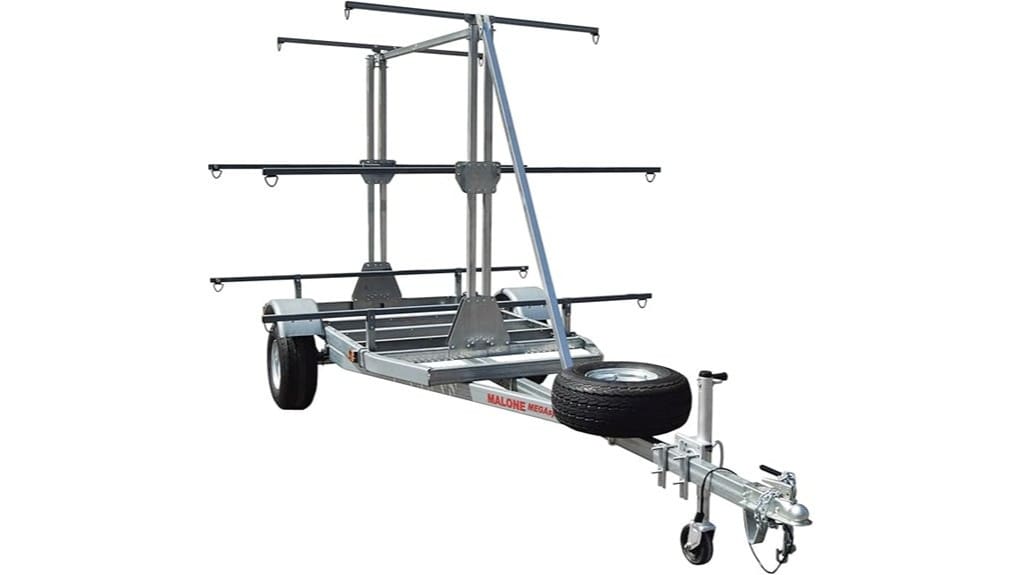
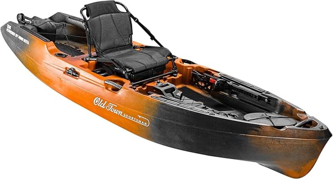
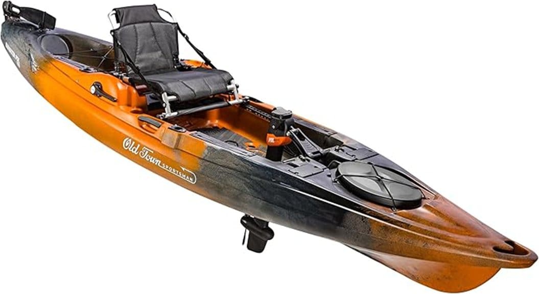
Choose Your Craft: Kayak, Canoe, Paddleboard, or Skiff
Pick a craft that matches the kind of day you want and the skills you’ve got, because the Ten Thousand Islands are a maze of skinny mangrove tunnels, shallow flats, and sudden open-water crossings that will test anything you bring. Choose a kayak for nimble work through creeks and quick retreat routes, or a canoe if you want roomy gear capacity but still need to shimmy through tight passages; a skiff makes longer runs possible, but watch draft, noise, and stick to marked channels. SUPs work if you’re steady and ready for currents and wind, but bring a leash and paddle float. Always plan around tides, pack a bailer or pump, PFDs, charts or GPS, PLB, water, sun protection, and consider renting or hiring a guide. Consider choosing a craft with a wide-beam stability to make exploring safer and more confident.
Pick a Launch Point: Everglades City, Chokoloskee, or Port of the Islands
When you’re picking a put‑in, think about what you want first: Everglades City gives you the busiest launch with visitor services and access to the Wilderness Waterway for longer routes, Chokoloskee feels like a shrimp‑boat village and shortens crossings into inner channels for calm, overnight trips, and Port of the Islands is a quieter northern entry if you’re coming from Naples. Check tides, wind, and where rentals or guides operate—bring a map or GPS, life jacket, dry bag, sun protection, and enough water and snacks before you push off. Start by choosing the route you want, then pick the closest launch that offers the services and crossings that match your plan, and don’t hesitate to ask local outfitters for current conditions. Also make sure you have the essential gear for sea kayaking and basic skills before heading into mangrove waterways.
Everglades City Launch Benefits
Everglades City is your go‑to for a full‑service launch, offering the busiest ramp, rental outfitters, and the Wilderness Waterway trailhead where most multi‑day permits and chickee reservations get handled, so you can get on the water with gear, maps, and a plan without hunting down services. You’ll find the Gulf Coast Visitor Center boat ramp as the focal point, even if visitor services are limited after Hurricane Ian, and outfitters nearby will fit your kayak, pack a dry bag, and point out tides and channels, so check permits first, load gear, and scout the tide table. Aim for the classic routes, bring bug repellent, a VHF or phone in waterproof case, map, water, and start early to own the day. For colder shoulder seasons, consider bringing a winter drysuit to stay warm and safe while paddling.
Chokoloskee Village Vibe
Slide into Chokoloskee if you want the quiet, working‑waterfront feel of a real shrimping village, because launching here puts you right at the southwestern tangle of mangrove channels and cuts hours off your paddle to nearby keys like Picnic Key or Sandfly Island. You’ll find boat launches, bait and tackle, and a couple of diners, but fewer tourist services than Everglades City, so bring water, snacks, sunscreen, and fuel if you’re on a skiff, and reserve backcountry permits for multi‑day Wilderness Waterway trips. Expect limited cell service, historic docks, and an intimate vibe, so check tides and weather, park with care, rig your gear on shore, and push off early for slack tide, keeping charts handy and a spare paddle reachable.
Port Of The Islands Access
For a quieter, less crowded put‑in, try Port of the Islands — it’s a good northern gateway to the Ten Thousand Islands, with a public boat ramp and more open water closer by, but you’ll need to be deliberate about timing, gear, and communications before you push off. You’ll find fewer outfitters here than Everglades City or Chokoloskee, so bring water, sunscreen, a paper chart, and a reliable paddle leash, and check tides and wind before you commit, because crossings to open water can turn choppy. Park remote, tell someone your plan, and expect spotty cell service; if you’re overnight, reserve Everglades National Park sites, pack tide‑dependent charts, and launch early for the calmest approach.
Day Routes That Work in Winter: Sandfly Island Loop and Nearby Loops
Starting the Sandfly Island Loop an hour or two after high tide gives you a much easier return, so plan your launch from the Everglades City Ranger Station accordingly and expect about 2.5–4 hours for the roughly 5‑mile circuit; you’ll cross open Chokoloskee Bay first, likely under an hour, then tuck into mangrove tunnels and paddle toward the 0.9‑mile Sandfly Island Trail where you can stretch your legs on a beach or explore a shell mound. You’ll want several liters of water, sun protection, and a waterproof map or GPS like Gaia GPS with NOAA charts, plus a compass and someone who knows your plan, since cell service fades. In winter, choose nearby creeks or bay loops from Chokoloskee Island or Port of the Islands to stay sheltered from cold-front winds.
Overnight and Multi‑Day Itineraries: Picnic Key to the Wilderness Waterway
If you’re planning an overnight at Picnic Key, start by packing several liters of drinking water per person, a headlamp for late-night star checks, and a tarp or bug net since summer insects can be brutal, and expect a white shell beach, Gulf views, and dolphins at dusk. For longer Wilderness Waterway trips you’ll want tide charts, NOAA charts or GPS plus paper maps as backups, confirmed backcountry reservations for chickees or campsites, and a route that times departures an hour or two after high tide to ease returns through tidal flats. If this is your first multi‑day paddle, consider renting from or hiring a guide in Everglades City to learn local launch differences, navigation tricks through mangrove mazes, and how to handle open‑water crossings safely.
Picnic Key Campsite Essentials
You’ll usually want to treat Picnic Key as your first serious stop on a Wilderness Waterway trip, so plan and pack like you’re camping away from help for a night or two: the sand is hard-packed white shell with Gulf views and great dusk dolphin watching, but there’s no potable water or facilities, limited cell service, and landing is easiest an hour or two after high tide, so bring several liters per person, a way to filter or treat water if you want extra safety, and a PLB or satellite messenger for emergencies. Once ashore, set camp facing the Gulf for views and wind shelter, stash gear in a waterproof daypack, check tide and wind, use insect repellent, lay out sun protection, and log your route with a chart or GPS tied to Everglades National Park booking.
Wilderness Waterway Planning
Before you push off from Picnic Key toward the Wilderness Waterway, take a breath and run through the basics so you don’t get surprised out on the mangroves: treat this as a real backcountry paddle—plan for up to 10 days if you’re going the whole 99 miles, reserve your campsites or chickees with Everglades National Park now, and pick a launch (Everglades City, Chokoloskee, or Port of the Islands) that matches your skill and daylight for the first crossing. You’ll pack like you mean it—several liters of water, sun protection, bug net, drybags, PLB or Spot, lightweight camp gear—and bring NOAA charts, compass and GPS, because mangrove channels hide cul‑sacs and tide‑dependent returns; check wind, tides, weather, and your reservations before you go.
Tides, Wind, and Weather Planning for Winter Paddles
Start by checking tide times and the marine forecast for the Florida Bays/10,000 Islands, because winter brings lower water and cooler air, but also stronger north/northeast winds and quick frontal shifts that can turn a short paddle into an exhausting slog. You’ll watch tidal timing, wind direction and gusts, and plan crossings for slack or outgoing tide, picking sheltered channels when the gulf gets choppy, because modest tide ranges still flip creek currents and ruin returns if you’re wrong. Check NOAA marine zones for sustained winds over 15–20 kt or gusts above 25 kt, pack warm waterproof layers, a VHF or PLB, and flag alternative exits like Everglades City, Chokoloskee, Port of the Islands, then tell someone your tide windows.
Navigation and Mapping: Charts, GPS Routes, and Route Timing
When you’re plotting a route through the Ten Thousand Islands, rely on NOAA nautical charts and a good GPS app like Gaia with NOAA overlays, and bring a paper chart and compass as a real backup in case your battery dies or you lose cell service. You’ll program waypoint tracks for the Wilderness Waterway and for shorter runs like the Sandfly Island Loop or Picnic Key approach, then check tides so you leave an hour or two after high for easier crossings, note wind limits for open water, and scale your plan—2.5–4 hours for the 5‑mile loop, up to 10 days for the full 99‑mile route with permits. Keep an eye on weather, carry spare power, and trust your compass when channels fork.
Winter Wildlife Encounters and Safety Around Manatees, Dolphins, and Birds
If you’re out in the islands this winter, expect more wildlife up close and plan to be slow and deliberate, because cooler, clearer water funnels manatees into sheltered creeks and dolphins often ride bows near launch points at dusk. You’ll see spoonbills, herons, ospreys, and skimmers too, so scan flats and mangrove edges, move quietly, and pick a respectful distance—manatees need at least fifty feet, dolphins don’t want to be chased. Stop if a resting manatee blocks a channel, wait rather than cutting through seagrass, and reduce speed in marked no-wake zones to cut stress and wake. Carry a VHF or PLB, keep situational awareness in tunnels, don’t feed or touch wildlife, and enjoy freedom responsibly.
Gear Checklist for a Southwest Florida Winter Kayaking Trip
You’ll want to outfit yourself a little differently for winter paddling around the mangroves, because clearer water and calmer air mean more close wildlife encounters and longer spells on the water, so plan gear that keeps you safe, comfortable, and respectful of animals. Choose a sea kayak or sturdy touring kayak with bulkheads for flotation, bring a spray skirt if you’ll cross open water, and pack a spare paddle with a leash. Carry navigation aids—waterproof charts, GPS or compass—and a PLB or SOS device, plus tide info. Bring 2–3 liters water, sun protection, salty snacks, insect repellent and a head net, dry bags, first aid, multi‑tool, and a light for after dusk.
Logistics, Permits, Campsites, and Local Services (Rentals, Guides, and Where to Eat)
Because logistics make or break a trip in the Ten Thousand Islands, start by lining up permits, transport, and a reliable launch point well before you pack, so you won’t be stuck scrambling for water or a shuttle at the last minute. You’ll need an Everglades National Park backcountry permit for chickees or beach camping on the Wilderness Waterway, so reserve early, plan days—short loops like Sandfly or multi‑day Thousand‑mile dreams—and book kayak rentals or a boat shuttle from Everglades City, Chokoloskee, or Port of the Islands. Carry several liters of water, tide charts, maps or GPS, sun gear, and an emergency PLB, and check local guides and eateries—Camellia Street Grill, Island Cafe, Triad—for meals and a place to rest before you push off.
Some Questions Answered
Can I Bring My Pet (Dog) on the Pontoon Boat or in Campsites?
Yes, you can bring your dog on pontoons and to many campsites, but rules vary, so check ahead; choose dog friendly camping spots, keep your dog on leash per park leash requirements, bring a life jacket sized for dogs, fresh water, shade, poop bags, and a towel, secure them during rough water, scout for ticks and heat stress, and have a backup plan if regulations or wildlife limit access, okay?
Are There Restroom Facilities Aboard the Pontoon Tour or on Nearby Islands?
Yes, restroom availability is limited, so you’ll want to plan, carry supplies, and ask operators first; on the pontoon you’ll usually find a small marine head or no facilities, and on nearby islands there may be portable toilets at popular campsites, but many spots have none, so pack toilet paper, hand sanitizer, a trowel or waste bags, and a privacy shelter, scout landing sites ahead, and skip remote coves if you need guaranteed facilities.
Is Fishing Allowed From the Pontoon or on Day Loops in the Ten Thousand Islands?
Yes, you can fish from many pontoon day loops, but you’ve got to follow spot rules, season dates, and bag limits, and practice catch and release when required for protected species, that’s regulatory compliance. Bring a Florida saltwater license, circle hooks for catch and release, pliers, a small net, and quick-release knots, check local bulletins before you cast, and ask your captain about no-fish zones so you stay legal and free to fish.
Are There Alcohol Restrictions on Paddles, Skiffs, or Campsite Areas?
Yes, you can have alcohol but there’re alcohol limits and container rules to follow, so pack responsibly: keep drinks in sealed, non-glass containers, avoid open consumption where signs or rangers prohibit it, and don’t overdo quantities that risk safety or fines. First, check posted rules or ask a ranger, bring trash bags, hydrate with water, and secure a sober paddler for skiff or campsite moves, because safety and respect keep trips legal and fun.
What Accessibility Services Exist for Visually Impaired or Hearing-Impaired Visitors?
Yes, you can get help: parks often offer audio guides and tactile maps, so ask rangers ahead, they’ll point you to downloadable audio files, appointments for tactile-map briefings, or loaner devices you can carry in a dry bag. Bring earbuds, a phone charger, a small flashlight for signaling, and a buddy if you want, and request captioned videos or sign-language interpreters for talks, so you’ll experience routes, campsites, and safety tips with confidence.